
The County of Marin is currently identifying locations for developers to construct 3,569 new housing units in unincorporated Marin County. As the County moves forward in this process by identifying thousands of “potential” parcels to fast track development in the next 8-years, we discovered another major issue, the eradication of A-60 zoning.
This blog post is dedicated to the importance of A-60 Zoning
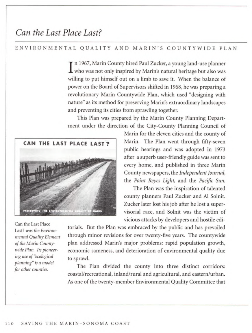
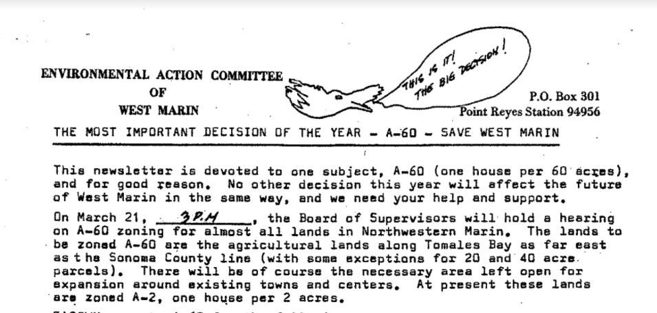
You may have heard about A-60 zoning for the first time if you watched the documentary, Rebels with a Cause or read about it in Marty Griffin’s book, Saving the Marin-Sonoma Coast. A-60 zoning was an essential part of stopping the plans to subdivide the western portion of Marin County and construct a freeway from central Marin County all the way to Point Reyes Station.
Specifically, A-60 zoning is a type of conservation zoning that safeguards agricultural lands from subdivision and development by allowing only 1 house per 60 acres of land. In other counties, like Napa, agricultural zoning may be up to 120 acres.
During the suburban boom of the 1960s, the countryside of Marin County was identified as areas ripe for development. A-60 zoning was the first step to stop irresponsible development plans that would have destroyed forever the landscapes we love in West Marin. A-60 zoning was passed on March 25, 1972, and was followed by the 1973 Countywide Plan that is hailed today as the basis for Marin’s environmentally sustainable and forward-thinking development that seeks to balance development with safeguarding our essential environmental ecosystems.
-
The infamous 1960s Countywide and West Marin Plans proposed the construction of a four-lane freeway to Point Reyes Station along Sir Francis Drake Boulevard and allowing for the subdivision and construction of thousands of housing units. At that time, developers viewed Marin’s agricultural lands as “vacant” areas ripe for development and suburban sprawl.
These pro-development plans were defeated in 1968, 1971 and 1973 due to intense public opposition to the destruction of the rural and coastal communties in Marin County.
In 1972, the County adopted A-60 zoning adopted A-60 zoning (a limit of one house per 60 acres in agricultural areas) to protect working agricultural lands, discourage land speculation for subdivision and development, and to protect open agricultural lands important for wildlife habitat and corridors.
In 1973, the County adopted an environmentally sustainable Countywide Plan that slowed growth and started Marin’s movement towards environmental and ecological land-use planning.
-
A-60 zoning districts identify areas suitable for commercial agricultural operations, and similar and compatible uses.
A-60 zoning limits development to one house per 60 acres of land.
50-year history of support across diverse organizations, including environmental, agricultural, and community groups as part of a multifaceted effort to prevent urban sprawl, protect public health and the economic, agricultural, and environmental vitality of Marin County.
EAC and other environmental organizations advocated for A-60 zoning to stop the development push that would have subdivided and paved over thousands of acres of important habitat.
A-60 zoning was created on March 25, 1972 with a narrow 3-2 vote that ended up being legally challenged and defended by the County of Marin all the way to the Supreme Court.
The development of A-60 zoning and the creation of the Inland-Corridor removed 136,000 acres of agricultural lands from potential subdivision and urban sprawl development [1]. A-60 zoning was created with a narrow 3-2 vote (March 25, 1972) and was then upheld and defended by the County of Marin all the way to the U.S. Supreme Court.
Since the adoption of A-60 zoning, limited rezoning of A-60 parcels has taken place, through the implementation of the 1980s Local Coastal Program and following the development of Community Plans that identified parcels for thoughtful rezoning based on community input and feedback.
The County has never rezoned A-60 parcels as part of the Regional Housing Need Allocation that occurs every 8-years.
-
Following the defeat of the 1960s Countywide and the West Marin Plans, the Marin County we know and love today with our open space preserves, public lands, and marine sanctuaries were all preserved and left now fall in the next generations hands to safeguard and uphold for the next generation.
1972 Point Reyes National Seashore and Golden Gate National Recreation Area Purchase Complete.
Marks vs. Whitney Supreme Court Public Trust decision protects Tomales Bay and California tidelands from infill.
1976 California Coastal Act regulates development of the California Coast.
1981 Point Reyes-Farallon Islands National Marine Sanctuary created.
1989 Cordell Bank National Marine Sanctuary created.
2015 the expansion of the Farallones National Marine Sanctuary expansion increasing the area of protection to 3,295 square miles and eliminating the threat from petroleum development.
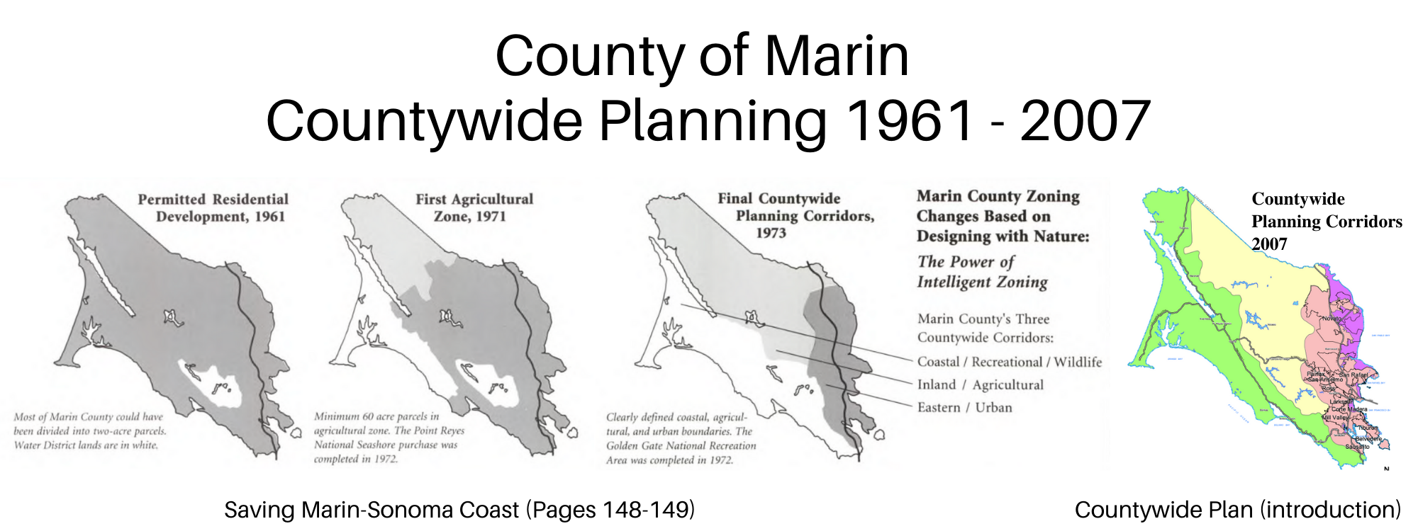
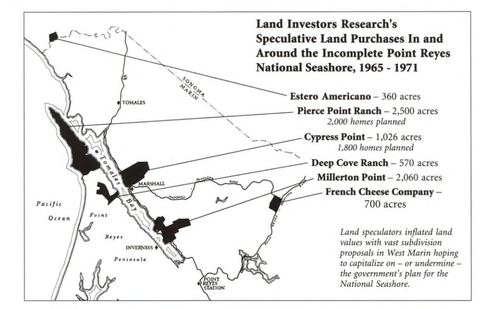
Images from the publication, Saving the Marin-Sonoma Coast (pages 148-149), by L. Martin Griffin and EAC’s archival newsletters from the 1970s.
A-60 LOCATIONS IN THE HOUSING ELEMENT
Embedded in the current Housing Element update there are three A-60 locations proposed that account for 282 of potential housing units.
Bowman Canyon, Novato Blvd, North Novato
Buck Center, Redwood Hwy, Blackpoint
Lucas Valley, 1501 Lucas Valley Road
As planning on the Housing Element progresses, the sites and numbers change. The June 2022 Draft Housing Element released to the public listed the Buck Center that would be rezoned to allow for more than 240 above-moderate housing units. From EAC’s attendance to the public workshops, we are aware there is an interested developer for this site.
-
All are located outside the Countywide Plan’s City-Center Corridor that would require adjustments to the Countywide Plan and not connected to essential services or near transportation corridors.
Bowman Canyon and Buck Center are outside of Novato’s Urban Growth Boundary that was recently established by the voters.
Bowman Canyon is located in the Plan Bay Area 2050 Priority Conservation Area.
All are examples of classic urban sprawl.
-
It appears that the County and their consultants are focused on the short-term goal to meet the state’s high housing total and have failed to consider the long-term trade off of undermining A-60 zoning. The last 50 years, the Board of Supervisors have been elected to uphold and honor the legacy of Marin’s sustainable development that has safeguarded the coastal and inland rural areas from urban sprawl.
The current Planning Commission and Board of Supervisors may be on a path that undermines Marin’s sustainable community planning that has protected public health and the economic, agricultural, and environmental vitality of the County.
-
Following the passage of the Coastal Act, the County of Marin created their Local Coastal Program and changed 60 zoning along the east shore of Tomales Bay to align with Coastal Zoning, essentially, the same protections but now included in California’s Coastal Zone.
Other changes to A60 parcels were made in local community planning, like Nicasio, where the local community made minor adjustments to A60 parcels based on the needs of the local Community Plans.
A60 zoning has never been rezoned in a Housing Element update that would change the environmental corridors to expand urban sprawl outside of the City-Center Corridor.
-
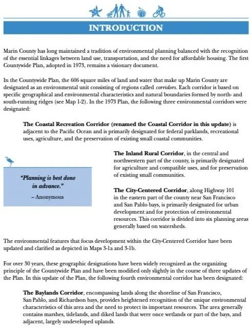
Since the 1970s, the Countywide Plan has been updated in 1982, 1994, and most recently in 2007 and continue to maintain the “tradition of environmental planning balanced with the recognition of the essential linkages between land-use, transportation, and the need for affordable housing. The 1973 Countywide Plan…remains a visionary document.”[2]
The current 2007 Countywide Plan, includes four environmental corridors, including: 1) Coastal Corridor; 2) Inland Rural Corridor; 3) City-Centered Corridor; and 4) Baylands Corridor that define community development guidelines.
-
The most urgent issue is these A60 zoning changes would be a slippery slope and set the stage for future erosions that would sacrifice the last 50-years of environmental and community planning for subdivision and sprawl.
Exactly what Marin has fought against for half a century. The below maps illustrate the expansion into the landscape.
January 2022 Housing Element Update
PROPOSED A-60 PARCELS

Yellow Parcels in above map are Bowman Canyon (near San Marin High School) and Buck Center (hillsides adjacent to 101). Combined 256 Housing Units proposed

Yellow Parcel in above map is Lucas Valley location that proposes the construction of 26 above-moderate income new Housing Units.
MARIN COUNTYWIDE PLAN ENVIRONMENTAL CORRIDORS
The Countywide Plan is the supreme planning document that informs and guides land-use and zoning within a jurisdiction.

Today, the rural and coastal communities of Marin that we know and love are in place due to the defeat of that irresponsible plan by organized community members and the majority votes of the Board of Supervisors who decided to safeguard the irreplaceable lands, waters, and biodiversity of Marin County from urban sprawl development.
WHAT YOU CAN DO
Call and write to the Board of Supervisors and Planning Commissioners asking for them to find alternate locations for housing that does not threaten the last 50-years of environmentally sustainable planning that has prevented urban sprawl and protected public health and the economic, agricultural, and environmental vitality of the County.

Footnotes:
Saving the Marin-Sonoma Coast, Page 149. Griffin, L. Martin.
The Countywide Plan 2007, Introduction. County of Marin.

